The address, the jurisdiction, and which Bengaluru this is
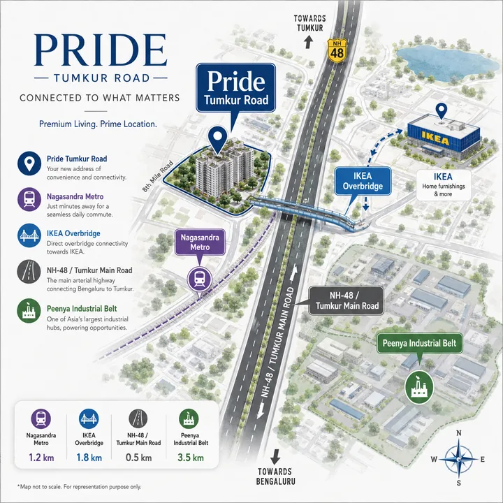
The compliance frame for this belt is Doddabidarakallu village, Yeshwanthapura hobli, Bengaluru North taluk, Bengaluru Urban district, PIN 560073. That is the string Karnataka RERA records for registered projects here, and it is the one that will appear on a sale deed, a khata extract and a plan sanction. "Nagasandra" is the metro-station and search label for the same ground; "Bagalakunte" (also written Bagalkunte and Bagalagunte) is the adjacent colloquial label. None of the three is wrong. They belong to different systems — revenue, transit and everyday speech — and a buyer who knows which is which will read documents faster than one who does not.
The zone label is genuinely split, and it is a live search question. Knight Frank classifies Tumkur Road inside its West Bengaluru micro-market, alongside localities such as Malleswaram and Vijayanagar. NoBroker files Nagasandra under North Bengaluru; 99acres carries the locality under both bangalore-west and bangalore-north URLs. There is no single correct answer, because these are commercial classifications rather than administrative ones — the administrative answer is Bengaluru North taluk. When you compare rates across portals, check which zone basket a figure came from before treating two numbers as comparable.
The geo pin published on this site is 13.0470 N, 77.5008 E. It is deliberately corridor-representative, sitting on the south side of NH-48 between the foot-overbridge landing and the station entrance. It is not a parcel centroid, and no distance on this page should be read as measured from a property boundary. The exact parcel and its survey number have not been published — which is itself part of the picture, and is dealt with at the end of this page.
Doddabidarakallu's nearest metro station, and how far IKEA is from Nagasandra metro station
Nagasandra, on the Green Line, is the nearest metro station — and it is close. The station node sits at 13.047954 N, 77.500142 E. It opened on 1 May 2015 and was the Green Line's north-western end of the line until the extension opened in November 2024.
The distances below are computed geometrically from verified OpenStreetMap and Wikipedia coordinates, anchored on the IKEA store centroid — the most stable reference point on this stretch. They are straight-line figures, not routed road distances. The gap between the two is small for the near stations and grows for the far ones.
| Green Line station | Straight-line from IKEA store centroid | Direction | Opened |
|---|---|---|---|
| Nagasandra (nearest entrance, "IKEA Side") | approx. 120 m | — | 1 May 2015 |
| Nagasandra (station node) | approx. 148 m | — | 1 May 2015 |
| Chikkabidarakallu | approx. 1,391 m | outward | 7 Nov 2024 |
| Madavara (terminus) | approx. 3,120 m | outward | 7 Nov 2024 |
| Dasarahalli | approx. 1,481 m | inward | 1 May 2015 |
| Jalahalli | approx. 2,368 m | inward | 1 May 2015 |
The one station missing from that table is the next one outward at 647 m, and it has a section of its own below, because the pre-launch material names it as the walk-to-metro anchor and that is the single largest factual correction on this page.
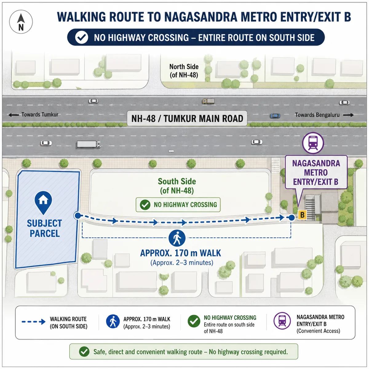
For a site on the south-west side of NH-48 directly opposite IKEA, the number that matters is better still: approximately 170 m in a straight line to Nagasandra's south-side entrance, signed B: MS Ramaiah Enclave Side. A real walk along the service road will be longer — on this street geometry, an estimated 200 to 250 m, or roughly three to four minutes on foot. That is derived from geometry, not a timed walk; do the timed walk yourself before relying on it.
The 153 m foot overbridge, and why it exists
IKEA Nagasandra sits on the north-east side of the highway, on a 14-acre parcel bought from the Bangalore Metro Rail Corporation, announced 31 May 2017 — the seller being BMRCL is precisely why the store sits flush against the station. It opened on 22 June 2022 at roughly 460,000 sqft and is IKEA's largest in India; its postal address reads Nelamangala–Majestic Service Road, Manjunatha Nagar, Nagasandra, Bengaluru 560073.
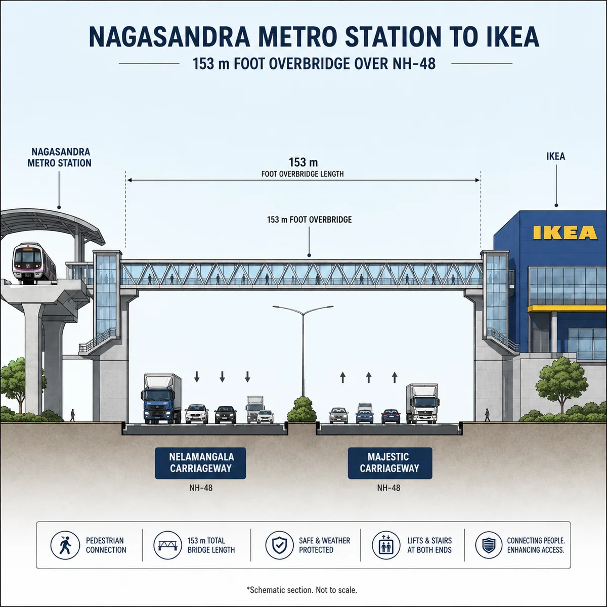
On 18 October 2023 a foot overbridge linking the station to the store was opened. It spans about 153 m, crosses both NH-48 carriageways, was funded and built by IKEA between April and October 2023, and is the second direct metro-to-retail connecting bridge on the Namma Metro network. IKEA reports that around a third of visitors to this store arrive by metro.
The overbridge is not a nicety. An Overpass sweep of the box 13.0455–13.0510 N / 77.4930–77.5040 E returns no pedestrian crossing node, no traffic signal and no vehicular subway anywhere on this stretch of NH-48. The only ways across on foot are that overbridge and one further footway viaduct roughly 400 m west. Deccan Herald has separately reported that BMRCL chose foot overbridges over subways on this road, and that passengers had been taking real risks to reach the station before the bridge existed. Here, the overbridge is the crossing, singular.
The station named in the pre-launch material, and the one that is actually nearest
The pre-launch material circulating for this project names Manjunathanagara — spelled variously Manjunatha Nagar, Manjunath Nagar and Manjunathanagar across BMRCL, Wikipedia and OpenStreetMap — as the walk-to-metro station. It is a real, operational station at 13.050090 N, 77.494446 E: elevated, two side platforms, opened to the public on 7 November 2024, and the next stop outward on the sequence Nagasandra → Manjunathanagara → Chikkabidarakallu → Madavara. But it is 647 m from IKEA and roughly 680 m from a parcel opposite it — about four and a half times farther than Nagasandra — so it is the wrong anchor for an address at this node.
The error is traceable, and understanding it is more useful than simply correcting it. IKEA's postal address contains the words Manjunatha Nagar — but that is the locality name, not the station. A writer matching the address string to a same-named station 650 m up the road lands on the weaker anchor: a name match that beat a distance check.
One further point makes Nagasandra the better anchor rather than merely the closer one. It has entrances on both sides of the highway — IKEA Side on the north at 13.0481929 N, 77.5003965 E, and B: MS Ramaiah Enclave Side on the south at 13.047824 N, 77.500786 E — so a south-side address reaches a platform without crossing NH-48 at all. And since the next station outward is one stop away regardless, you gain the near station without losing the far one.
Riding the Green Line from Nagasandra
Nagasandra is on the Green Line, not the Purple — a question asked often enough on this locality to be a standing autocomplete. Inward, the line runs Nagasandra → Dasarahalli → Jalahalli and on through Yeshwantpur to the interchange at Majestic, continuing to Silk Institute at the southern end. Outward it reaches the terminus at Madavara. Nagasandra and Madavara are not the same station; Madavara is roughly 3.1 km further out and became the terminus only in November 2024.
That extension changed what this address is. The Nagasandra–Madavara section is 3.14 km with three new stations, cleared by the Commissioner of Metro Railway Safety on 4 October 2024 and opened on 7 November 2024 at a stated Rs 1,168 crore including Rs 152 crore of land acquisition, expected to serve about 44,000 additional daily commuters; the network reached 76.95 km and 69 stations. Nagasandra stopped being the end of the line and became a mid-line station, with terminus parking pressure pushed further out — a quiet but real improvement for anyone boarding here in the morning.
One thing we will not publish is a fare or a door-to-door journey time to Majestic: we have no verified BMRCL figure for either, and both change. Check them on BMRCL's own site for the week you travel, and time one peak-hour trip yourself before letting a commute assumption drive a purchase.
NH-48 at this point: a divided highway with a single crossing
The site fronts NH-48 / NH-75, the Bengaluru–Tumakuru highway, carried here as two separated carriageways with service roads either side. At longitude 77.5003 the carriageways run at roughly latitude 13.0476, with IKEA's centroid about 190 m north of them — which is how the north-east / south-west geometry of this node is established without relying on any marketing claim.
That matters more than it sounds, and it is the single most important thing to understand about distance here. A median-divided highway with no signalised crossing inverts nearest-landmark rankings. Something 200 m away as the crow flies but on the far side of the carriageways can be a 600 to 700 m walk via the overbridge; something 400 m away on your own side is a 400 m walk. Any distance quoted for this address — by us, by a portal or by a sales desk — should carry the question which side of the highway is that on, and how do I get across? The south-side station entrance keeps coming up on this page because it is the fact that makes the walk short.
Outward, NH-48 runs towards Nelamangala; inward it runs to Goraguntepalya and the city. The commute pressure point is Goraguntepalya, where peak waits at the signal have been reported at 20 to 30 minutes. A flyover already carries NH-48 over that junction, roughly 2 km in each direction. The BDA has invited tenders for a detailed project report on a 4.4 km six-lane tunnel road from Tumkur Road to BEL Junction — DPR stage only, not funded, not sanctioned, not under construction, no completion date. Treat it as a possibility, not a pipeline.
You will also see the Satellite Town Ring Road offered as an airport story for this address. It is not one: the STRR is a 280 km, roughly Rs 15,676 crore NHAI ring linking satellite towns, four of its six packages complete and the remaining two stated as targets for late 2026. Kempegowda International is about 27.8 km away in a straight line from our corridor pin and materially longer by road. The genuinely strong connectivity story here is the metro, and it is strong enough not to need help.
Apartments near IKEA in Bengaluru: what the landmark buys, and what it does not
The search string apartments near ikea bangalore is real, national-level demand — it is the first suggestion Google returns worldwide for the seed "apartments near ikea", ahead of Winnipeg, Jacksonville and Hyderabad. What it currently resolves to is brand names rather than an address, which tells you the query is under-served rather than that the landmark is decisive.
Be clear-eyed about what a 460,000 sqft furniture store next door is actually worth. It is a genuine landmark for directions, a large food hall, and — because IKEA paid for the overbridge — the reason a pedestrian link across NH-48 exists at all. It is not a mall, not a grocery run and not a school district, and it brings weekend vehicle volumes onto the service road that a resident notices on a Saturday. The honest framing: the metro station is the infrastructure, and IKEA is the amenity that funded its last 153 m.
Where people work within reach of this address
This is not an IT-corridor address and should not be sold as one. The employment base around it is manufacturing, engineering and logistics, with retail layered on more recently.
The Peenya industrial belt is the dominant employer nearby: more than 2,100 industries, weighted towards chemicals, leather, pharmaceuticals, plating and polymer engineering. It is frequently described as one of the largest industrial zones in South-east Asia — a claim worth reporting with its hedge intact, because even the belt's extent is contested: one source cites the notified core at 1,461.46 acres, roughly 5.9 sq km, while Citizen Matters cites around 40 sq km for the wider belt. Both cannot describe the same thing.
Closer in, OpenStreetMap names a 25.10-acre Kennametal parcel about 0.5 km from our corridor pin and a Karle industrial site about 0.35 km away, both on the north side of the highway. The larger industrial land here sits on IKEA's own side rather than opposite it, because the south side is already a residential cluster.
For office employment the answer is the Green Line, not the neighbourhood. Yeshwantpur is a metro and rail destination inward on the same line, and the interchange at Majestic opens the rest of the network. If your work is in Bengaluru's eastern or southern office markets, this address is a metro commute with an interchange — price that in honestly rather than reading a short walk to a station as a short commute.
Flats near Nagasandra Metro Station: the neighbours already here
The ground behind the NH-48 frontage on the south side is an established residential cluster, not vacant land — a positive for services and a constraint on how much more can be built. Distances below are straight-line from our corridor pin and should be treated as accurate to roughly ±150 m.
| Neighbour | Straight-line from our corridor pin | Note |
|---|---|---|
| Arvind Oasis | approx. 0.2 km | 3.15-acre residential parcel |
| Sobha Ruby / Ruby Platinum / Elite / Aspire | approx. 0.25 km | 16.57-acre parcel; Sobha Garrison sits immediately behind the frontage |
| Nagasandra BWSSB site and Phase I sewage plant | approx. 1.0–1.1 km | 11.17 acres; 20 MLD plant on 7.74 acres |
| Godrej Gold County | approx. 1.2 km | 13.47-acre residential parcel |
| Bengaluru–Jindal GAIL pipeline crossing | approx. 1.2 km | east |
| Prestige Jindal City | approx. 1.6 km | 32.37 acres, the corridor's largest scheme |
Two named new launches set the current pricing and quality reference on this node. Brigade Lumina — 3.97 acres, 416 residences, 2 and 3 BHK at 1,099 to 1,819 sqft super built-up, registered with Karnataka RERA on 23 March 2026 — is about a kilometre away. Godrej Tiara at the Goraguntepalya end is 5 acres, three towers of 30 floors, 346 units at four apartments per floor. Sipani Samuha on Tumkur Main Road registered on 31 January 2025, and Sipani has a second, upcoming project on this road marketed on almost exactly the metro-plus-IKEA phrasing this node invites. Anyone calling this micro-market uncontested is not looking at it.
Schools, hospitals and daily retail: what we can name, and what we will not
Here we are going to do what most microsites on this corridor do not, and say what our sources do not establish.
Our verified source set for this belt names Sacred Heart College of Nursing and the MS Ramaiah Enclave residential precinct on the south side, and IKEA Nagasandra as the major organised retail anchor. It does not contain a distance-checked list of schools and hospitals within 2 km of this parcel. Plenty of pages here publish such lists; we will not publish one we have not checked, because a school name with a confident-looking distance beside it is exactly the kind of detail a buyer relies on, and exactly the kind that gets copied between microsites until nobody knows where it came from.
Closing that gap takes an afternoon. Set the origin to the actual parcel — once the developer gives you the survey number — and measure road routes, not straight lines, to the two or three schools and the one hospital you would genuinely use, at 8:30 am on a weekday. On a corridor where a divided highway with one pedestrian crossing sits between you and half your options, the road answer and the straight-line answer are different answers, and only one is the one you live with.
Infrastructure in flight, with honest status
| Item | Status as at August 2026 | Date |
|---|---|---|
| Nagasandra–Madavara Green Line extension | Complete and operating | Opened 7 Nov 2024 |
| IKEA-funded 153 m foot overbridge | Complete and open | Opened 18 Oct 2023 |
| Premium FAR policy (Karnataka) | In force; upheld by the High Court of Karnataka | Gazetted 21 Feb 2025; upheld 15 Jun 2026 |
| STRR (280 km) | Four of six packages complete; two stated as targets for late 2026 | Targets, not confirmations |
| Tumkur Road – BEL Junction tunnel (4.4 km, six lanes) | DPR stage only — tenders invited for the report | No funded date |
The Premium FAR policy belongs in a location discussion because it explains the skyline you will be looking at in ten years. Gazetted on 21 February 2025 under notification UDD 78 MNJ 2024(E) and upheld by the High Court on 15 June 2026, it allows a purchased FAR uplift plus a TDR component on qualifying road widths. In plain terms: on a wide arterial like NH-48, buildings here can now go materially taller than RMP-2015's base allowance, subject to the developer actually buying that entitlement. The arithmetic sits on the master plan page; the location consequence is simply that low-rise is not the future of this frontage.
What to weigh before you buy on this corridor
Water is the first question, and it is not rhetorical. Peer-reviewed sampling of 116 borewells in the Peenya industrial area recorded a Heavy metal Pollution Index of 846 pre-monsoon and 336.7 post-monsoon against a critical value of 100. Roughly 90% of groundwater and surface samples were unfit for drinking, and the oral-ingestion hazard index exceeded 1.00 for chromium, mercury and arsenic in both seasons; many industries in the belt discharge untreated effluent into unlined drains. That is not a reason to rule out the address, but it is a reason to make the water source a written condition. Ask whether the scheme is on piped BWSSB supply with no borewell dependence, and get the answer before you book. Note carefully that BWSSB pipes treated water from the Nagasandra plant to Peenya industry on a separate, non-potable industrial line — that is not domestic supply, and the two must never be conflated in a sales conversation.
The prior use of the ground matters more than usual here. This is the edge of a chemical and plating belt, and any scheme with deep basements is excavating into it. Prior-use contamination history and the Karnataka State Pollution Control Board consent record for the parcel are legitimate diligence items. We do not know what stood on this parcel or what it did, and we are not going to guess.
The crossing constraint is permanent until someone builds another bridge. One foot overbridge and one footway viaduct are the pedestrian crossings on this stretch; everything on the far side is a bridge trip.
The commute has a known choke point. Goraguntepalya at peak is 20 to 30 minutes of waiting, and the tunnel that would relieve it does not exist beyond a tender for a report.
Air quality beside an industrial belt is a fair question our sources do not answer. We found no locality-level air-quality dataset for Nagasandra we would stand behind, and we would rather say so than publish a comfortable sentence. On flooding, the honest answer is "not found" — Peenya appears in general monsoon reporting, but no Nagasandra- or Tumkur-Road-specific chronic flooding record surfaced. That is absence of evidence, not evidence of absence; ask longer-standing residents on the service road.
The micro-market is contested. Brigade, Godrej, Sobha, Prestige, Arvind and Sipani all hold ground within about two kilometres, several with RERA registrations this project does not have. That is good for resale liquidity and bad for pricing power, and both halves are true at once.
The one location claim we cannot settle
Two location readings are in circulation for this project and they cannot both describe the same parcel.
OpenStreetMap geometry places two amalgamable parcels directly opposite IKEA on the south-west side of NH-48 — an unnamed 2.51-acre industrial plot and an adjacent 1.10-acre construction parcel, 3.61 acres together, with a 0.81-acre recreation ground between them — putting a site there approximately 170 m from Nagasandra's south entrance. Separately, aggregator listings for an existing registered scheme roughly 500 m west along this same road place that scheme at about 300 m from the next station outward and 1 km from Nagasandra — the inverse ranking.
Both readings are internally consistent. They simply describe different parcels. Which side of NH-48 this project sits on is unresolved, and we are not going to resolve it by choosing the more flattering option. Every distance on this page carries its origin, so you can re-measure the moment a survey number exists.
What to verify
- The survey number and the parcel boundary. One field settles the side-of-highway question and every distance that hangs off it. Ask for it in writing before anything else.
- The Karnataka RERA position. This project is not registered. Check the current status yourself at rera.karnataka.gov.in. A Karnataka project registration takes the form
PRM/KA/RERA/.../PR/...; a number containing/AG/is an agent registration, not a project registration, and is not a substitute. - The walk, timed. Walk from the parcel to Nagasandra's B: MS Ramaiah Enclave Side entrance at 9 am on a weekday, then walk the overbridge. Our 200 to 250 m estimate is geometry; your stopwatch is evidence.
- The water source, in writing. Piped BWSSB supply or borewell? Get it on paper, and do not accept the Nagasandra treated-water industrial line as an answer.
- Road distances, not straight lines, to the schools, hospital and workplace you would actually use.
- The sanctioned plan and land extent, when they exist. Until a plan is sanctioned and a registration is granted, every structural figure in circulation for this project — including the ones we publish with their arithmetic shown — remains indicative.
Enquire about Pride Tumkur Road
Register a non-binding interest and we will send you the survey number, the sanctioned plan, the AAI height clearance and the Karnataka RERA certificate as each one is published. Until they are, we will tell you plainly that they do not exist.
Register Your InterestPride Tumkur Road Location – Frequently Asked Questions
What is Pride Tumkur Road, and where exactly is the site?
It is a pre-launch apartment scheme on Tumkur Main Road (NH-48), opposite IKEA Nagasandra, in west Bengaluru. The legal address frame is Doddabidarakallu revenue village, Yeshwanthapura hobli, Bengaluru North taluk, Bengaluru Urban district, PIN 560073 — that is the string Karnataka RERA records for this belt, while Nagasandra is the metro-station label and Bagalakunte (also written Bagalagunte) the adjacent colloquial one. The pin published on this site, 13.0470 N 77.5008 E, is corridor-representative: it sits on the south side of NH-48 between the foot-overbridge landing and the Nagasandra station entrance. It is not a parcel centroid, because neither the exact parcel nor its survey number has been published. One honest consequence follows: which side of NH-48 the site sits on is not settled, and we write it as unsettled rather than picking a side.
Does a 98 m tower need an airport height clearance?
Yes. An Airports Authority of India height NOC is required within 20 km of the aerodrome reference point of a VFR airport and 56 km of an IFR one, and four aerodromes are in range of this corridor pin: Jakkur Government Flying Training School at 11.8 km and Yelahanka Air Force Station at 15.0 km, both inside the 20 km radius, plus HAL Bengaluru at 21.1 km and Kempegowda International at 27.8 km, both inside the 56 km radius. KIAL and Jakkur clear through the NOCAS portal; HAL and Yelahanka require direct defence NOCs outside NOCAS. Whether 98.35 m is the architect's number or an AAI-permissible elevation is unknown, and we will not guess. Worth noting separately: 98.35 m would not be the tallest on this corridor in any case — CNTC Presidential Tower at Yeshwantpur is 161 m and Aquila Heights Polaris at Jalahalli is 105 m.
What is Nagasandra famous for, and what is the PIN code?
The PIN is 560073, covering Doddabidarakallu, Nagasandra, Bagalakunte and the Manjunatha Nagar locality. What the name is known for, in practice, is two things. First, IKEA's largest Indian store — about 460,000 sqft, opened 22 June 2022 on a 14-acre parcel bought from BMRCL — and the metro station that serves it, which is why "apartments near IKEA Bangalore" is a live national-level search string rather than a local one. Second, and less comfortably, its position on the edge of the Peenya industrial belt. There is also significant municipal water infrastructure roughly 1.0 to 1.2 km south-west: a BWSSB site and the Nagasandra Phase I 20 MLD sewage treatment plant, with a further plant under construction nearby.
How far is IKEA from Nagasandra metro station, and is there a walkway?
148 m, and yes. IKEA Nagasandra sits on the north-east side of NH-48 on a 14-acre parcel bought from the Bangalore Metro Rail Corporation, announced 31 May 2017 — the seller being BMRCL is precisely why the store sits flush against the station. It opened on 22 June 2022 at roughly 460,000 sqft and is IKEA's largest store in India. On 18 October 2023 a foot overbridge linking station to store opened: about 153 m, spanning both NH-48 carriageways, funded and built by IKEA between April and October 2023, and the second direct metro-to-retail connecting bridge on the Namma Metro network. IKEA reports that around a third of visitors to this store arrive by metro.
Which metro station is actually nearest - Nagasandra, or the one the pre-launch material names?
Nagasandra, by a wide margin, and this is the single largest factual correction on this site. Nagasandra Metro Station on the Green Line is about 170 m in a straight line from a site opposite IKEA; Manjunathanagara is about 680 m — roughly four and a half times farther, and 647 m from IKEA itself. The confusion is traceable rather than random: IKEA's postal address contains the locality name "Manjunatha Nagar", which is not the same thing as the station of that name 647 m up the road, and a name match beat a distance check. Manjunathanagara is a real, operational station — elevated, two side platforms, opened to the public on 7 November 2024 — it is simply the wrong anchor for an address at this node.